Modeling Disparities in Accessibility to Essential Services Under Disasters Using Large-scale Mobility Data
By: Zhiyuan Wei (zwei7@buffalo.edu)
Advisor: Sayanti Mukherjee, PhD
Department of industrial and systems engineering
Project Objetives
•To understand how people get access to a variety of critical facilities
•To analyze human mobility patterns in relation to income segregation patterns before, during, and after a natural disaster
•To reveal mobility disparities between low- and high-income areas
Data and Results
• Large-scale mobile phone data provided by the SafeGraph company is used
• A dynamic mobility network is constructed to describe the footprint of people, leveraging optimization techniques and iteration methods
• People living in low-income areas tend to have low access to essential service before, during, and after the disaster
• Mobility patterns in response to the disaster are heterogeneous and influenced by socioeconomic status
• Facilities with smaller catchment areas are found to have higher degree of segregation
Significance
• This project offers a new venue for better understanding human behaviors under natural disaster through human mobility networks. This could inform equitable resource allocation in disaster management
• The next step is to develop a human-centric framework for resource allocation to ensure the fairness and efficiency
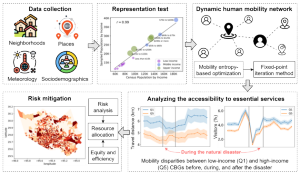

Overview of the proposed methodological framework