Quantifying and Attributing Ice Sheet Model Divergence Across Greenland’s Drainage Basins
By Ben raimondo, University at Buffalo
Advisors: Sophie Nowicki, Earth science, University at Buffalo
Advisors: naveen senthil, University at Buffalo
Project Objectives
•Identifying regions where Greenland ice sheet models disagree
•Improving sea level rise projections
•Understanding model limitations and assumptions
Data and Results
• Used ice thickness change data from participating models in various experiments.
• Applied PCA and K-Means clustering on the dataset at each of the seven IMBIE Greenland drainage basins.
• Used SHAP to attribute model features to K-Means clusters.
• Mapped back to physical space through spatial maps of each basin in the PCA space.
• Found that certain models like VUW-PISM consistently diverge, while others can be affected by climate models/scenarios and basin physics.
Significance
• Populations affected by sea level rise are relocated to a safer area.
• Better model predictions allows for more accuracy in determining future sea level rise due to the Greenland ice sheet.
Publication or Conference
Raimondo, B., Nowicki, S. Senthil, N. (2025). Quantifying and Attributing Ice Sheet Model Divergence Across Greenland’s Drainage Basins. Cryosphere Student and Early Career GeoBurst Session. American Geophysical Union, New Orleans, LA, USA
------------------------------------------------------------------------------------------------
Center for Geological and Climate Hazards
Interdisciplinary Research Experience for Undergraduates in Atmospheric and Geological Hazards
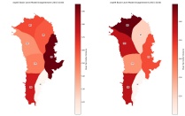

Disagreement map of Greenland’s basins, calculated by taking the distance of the furthest outlier models from the main cluster’s centroid. Darker indicates outliers are further away, lighter indicates they’re closer. (a) exp05, (b) exp09