Creating and Assessing an Unconventional Database of Dust Storms Around the World
By Sage Keidel, University at Albany
Advisors: andew crooks, geography, University at Buffalo
Advisors: Stuart Evans, GEOGRAPHY, University at Buffalo
Project Objectives
•Can we use social media as a more comprehensive method of tracking dust storms?
•Can OpenAI software decipher if an image is one of a dust storm?
Data and Results
• Thousands of image results from searching for relevant key terms.
• Many results are irrelevant to this project.
• Plotting the geolocated photos on a map revealed a pattern like that of a population map.
• OpenAI can decipher images at a decent level; but is often incorrect when it comes to non-meteorological airborne dust (ex. a horse kicking up sand).
• OpenAI may change the response between runs; but maintains high confidence.
Significance
• Social media can provide us with data that otherwise would have been missed.
• Analyze the accuracy of OpenAI’s results, correlate events to archived meteorological data, evaluate the impact of dust storms on traffic and health around the world, and expand the project to further social media sites.
------------------------------------------------------------------------------------------------
Center for Geological and Climate Hazards
Interdisciplinary Research Experience for Undergraduates in Atmospheric and Geological Hazards
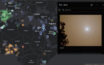

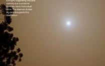
Map of all dust-relevant search results on Flickr and an example of the same image processed by OpenAI.