Geology Field Camp
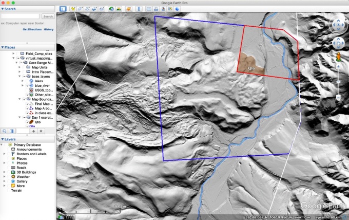

Figure 1. Jason Briner, PhD led the students through creating a surficial geologic map using LiDAR overlays in Google Earth Pro. Shown here is a portion of the map area in Colorado, USA.
Field Camp during a Pandemic: Armchair Field Mapping in 2020
By Gregg, Boyle, Meehan, Briner and Jadamec
Our department has offered a summer capstone experience course (GLY 407/507: Geological Field Training) for over 50 years. UB’s field course (lovingly referred to as “field camp”) immerses students in an intensive, 4-week field mapping course in Colorado and Utah, during which we hope they learn how to create accurate and presentable geologic maps from their own, painstakingly collected field observations. Students must also learn how to comfortably sleep in a tent during night-time temperatures ranging from the upper 20’s to the mid-70’s (Fahrenheit).They learn that they can continue mapping through rain, sleet, snow, baking heat and blinding wind; they discover that they have the depth of character to push themselves—physically, intellectually, emotionally—beyond what they had thought possible; and they learn the social skills required to work in groups that are not of their own choosing. These experiences are invaluable and can be life-changing.
Unfortunately, COVID-19 required that we cancel field camp—for the first time—in 2020. We recognized that we had 16 undergraduates who needed this class to graduate with their B.S. in geological sciences, so we created a Virtual Mapping Course (GLY 478: Advanced Field Methods). This class met remotely from July 6 – August 14 on MWF from 9:30 a.m. to noon and provided the students with at least some of the skills that they would’ve learned in a more traditional, field-based mapping course.
Our usual field mapping course takes the students through a series of field sites. Students spend about a week mapping each site, and the geologic complexity increases with each map area. Similarly, we divided the virtual mapping course into a series of modules with increasing demands. Each module ran for a week or more.
Kimberly Meehan, PhD taught the first module, and focused on making sure all students were able to use the required software for the course. Jason Briner, PhD then took students on a virtual field trip to the mountains of Colorado and showed them how to use Google Earth to make a surficial geology map of glacial deposits. From there, James Boyle, PhD (the lead instructor for the entire course) introduced detailed field videos and photographs of Western New York stratigraphy; students used these observations to construct stratigraphic columns and interpret the region’s geological history. Tracy Gregg, PhD asked students to practice mapping Mars-analog terrains in northern Arizona (specifically SP Mountain and Meteor Crater), relying on Google Earth and ASTER datasets provided by Bea Csatho, PhD. With that knowledge, students were able to create a geologic map of a small area (<30,000 km2) of Mars. Finally, PhD Margarete Jadamec’s module focused on structural geology and principles of geologic mapping using virtual tours and field data collected from the Brooks Range in Alaska. Students used previously collected strike and dip measurements, rock descriptions, high-resolution outcrop photographs, and Google Earth perspective views to systematically work through the field area and construct a geologic map on a paper topographic map base. By time-releasing data to the students for sub-regions, students were able to see the geologic structure emerge as the virtual field mapping progressed. In this way, students gained the critical experience of recording observations on a geologic map and learning how single outcrops relate to the larger structure of the region.
In the end, the students learned how to generate geologic maps using diverse datasets, and were able to thoughtfully separate their observations from their interpretations. Although the students missed out on the traditional field camp experiences, they were able to explore and deepen their mapping skills through this virtual mapping course. Most importantly: they were able to graduate.
We cannot yet know whether we will be able to return to our traditional field training course in the summer of 2021. Although we hope to take our students to geologically fascinating places in the American Southwest this coming summer, we acknowledge that we may need to further develop our remote instruction for a new batch of students. Furthermore, we realize that virtual field instruction is more accessible (financially and physically) for many of our students than is the traditional field course. We hope that both virtual mapping and field training will continue to have a place in our department’s future.