Software Developed by UB Geographers is the First to Show How Quickly Fire Companies Respond to Urban Blazes
Program can provide lawmakers guidance on tough decisions to close firehouses
Release Date: January 29, 2004 This content is archived.


BUFFALO, N.Y. -- Few municipal acts are as politically risky as the announcement of the closing of a firehouse: City governments cite population shifts and underutilization of resources while unions, neighborhood activists and local politicians charge that innocent lives are at risk.
Now University at Buffalo geographers have developed the first software tool that determines precisely how long it takes for fire companies to reach fires, medical emergencies and sites of other rescue operations in order to assess how well a city is being served by the quantity and distribution of its firefighting resources.
The software, which is applicable to any city, is called Emergency Response Time Assessment System (ERTAS).
"Everything comes down to response time," said Jean-Claude Thill, Ph.D., professor in the Department of Geography in the UB College of Arts and Sciences and co-developer of ERTAS with Irene Casas, Ph.D., UB assistant professor of geography.
"We wanted to look at how long it took to get the first fire company to the site of the emergency and how long to get a 'full first-alarm assignment' response, when all firefighters have arrived so they can begin to work," he explained.
National guidelines state that in areas like Buffalo, served by professional fire departments, 90 percent of the time it should take four minutes or less for the first company to reach the emergency site and eight minutes or less for deployment, when all firefighters have arrived, said Thill.
The UB geographers developed the tool in response to a request in 2002 from the Buffalo Common Council, which was struggling to determine which fire stations to close as a result of population shifts in the city and severe budgetary problems.
"Our primary goal was originally not to figure out how many firehouses could be safely closed," said Thill, "rather, it was to assess how Buffalo was complying with the National Fire Protection Association guidelines. As the project advanced and as the unique capabilities of our software became apparent to public officials, we were asked to advise them on the safety of alternative firehouse closing plans."
The software calculates exactly how long it takes fire companies to reach a blaze depending on the types of streets on which they have to travel, how many seconds it takes specific vehicles to turn on those streets and how long it will take fire companies in neighboring areas to reach an emergency site if all companies from the local fire station are deployed already at other locations.
"A big problem with existing software packages is that they deal with static situations," said Casas. "They assume that all fire companies are available and simulate the travel time from the station to a blaze. But multiple emergency calls can occur with some frequency within a single fire company's jurisdiction and our simulations are the first that can accurately portray that."
For example, if an alarm rang in a Buffalo firehouse at 12:01 a.m. on January 1, 2001, the code looked for the five closest companies to send.
"Once that happened, those five were no longer available to the simulation, so if shortly thereafter a fire broke out two blocks away, the software would seek out the next closest fire companies to send," said Thill.
The UB geographers mapped 125,000 911 calls made within the city of Buffalo from 1998 to 2002, using an innovative combination of algorithms and geographic information systems (GIS) techniques.
"Ours is the first software that can accurately depict the time it takes for a specific fire company to respond to fires and other emergencies, based on 911 calls received," said Thill.
The software's mapping capabilities also were critical since part of the objective of the UB researchers was to predict how the closing of a specific fire station would affect response times in neighborhoods throughout the city.
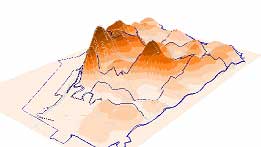
"With our software, it is possible to visualize the distribution of response times throughout the city, and we did identify some neighborhoods, such as South Buffalo, which were not as well-protected as the local population should expect," said Thill.
Simulations conducted on the UB software revealed that several of the firehouses that had been closed temporarily could remain closed and that several others also could close without a negative impact on firefighting capabilities. However, they also revealed that some redistribution of firehouses needed to be considered to enhance the service offered by the Buffalo Fire Department.
Media Contact Information
Ellen Goldbaum
News Content Manager
Medicine
Tel: 716-645-4605
goldbaum@buffalo.edu